Wild Rice Management and Restoration
Restoration of Keweenaw Bay Indian Community’s Sand Point Sloughs increases cultural and ecological functionality
Significant progress made but additional restoration could counter-balance losses
Recent restoration efforts on eight acres at Keweenaw Bay Indian Community’s (KBIC’s) Sand Point Sloughs have improved the cultural and ecological functionality of the sloughs’ Gichi-manidoo gitigaan (The Great Spirit’s Garden); however, given the significant historical losses, much more restoration is needed. Based on methods applied in this study, it would take an additional 175 acres of similar Manoomin (wild rice) restoration to counter-balance the lost cultural and ecological functionality that have occurred over time. This is equivalent in scale to 22 times the current restoration efforts at the sloughs. In addition, future restoration actions will need to be adaptive to respond to changing climate conditions.
Threats to Manoomin at Sand Point Sloughs
|
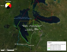
About Sand Point Sloughs Sand Point Sloughs are relatively shallow backwater sloughs connected to Lake Superior that are culturally important to the KBIC. Native people used this area for hundreds of years, as indicated by the existence of ancient burial grounds and stories that have been passed on through oral tradition (KBIC, 2003). Manoomin is believed to have been present in Sand Point Sloughs prior to the 1900s (Ravindran et al., 2014). Today, the site contains the KBIC Pow Wow grounds, a traditional healing clinic, extensive wetlands, and Manoomin beds. A marina, campground, lighthouse, and recreational beaches signify the community’s appreciation of this area. This area also holds ecological value as habitat. It provides for a number of species including medicinal plants, insects, fish, and other non-human relatives.
|

Connected to Lake Superior, Sand Point Sloughs is part of a dynamic coastal system. In the early 20th century, a copper ore processing plant, Mass Mill, operated on the west side of Keweenaw Bay on the south shore of Lake Superior. During the copper ore processing, approximately six billion pounds of mine tailings, locally known as stamp sands, were disposed into Keweenaw Bay. Lake currents continue to carry these tailings southward and redeposit them onto Sand Point, located just four miles south of the Mass Mill. Sand Point has an extensive beach area with approximately 2.5 miles of lake front and is connected to the sloughs. These tailings contain high concentrations of heavy metals that have the potential to cause environmental harm.
More recently, Sand Point Sloughs has been affected by regional hydrologic conditions – including higher water levels – that are occurring at a regional scale and are beyond local control. As a plant species sensitive to changes in water level, higher water levels have negatively affected the establishment and abundance of Manoomin in Sand Point Sloughs. The sloughs’ connection to Lake Superior also opens the pathway to aquatic invasive species, such as carp and reed canary grass. Carp, for example, are bottom feeders that uproot Manoomin (Premo et al., 2014). Manoomin abundance may be impeded by competing native vegetation, such as ginoozhegoons (pickerelweed); and by excessive browsing by wildlife on new stands, such as waterfowl.
 Lake Superior Manoomin Cultural and Ecosystem Characterization Study
DRAFT REPORT pt. 1 | DRAFT REPORT pt. 2 | DRAFT REPORT pt. 3
 A little over a year ago KBIC-NRD joined in a partnership with our sister Great Lakes Tribes, Federal and State agencies , including NOAA (National Oceanic and Atmospheric Administration). The purpose of this partnership was to create a document for indigenous communities, tribal and non-tribal governments, and organizations who are working to actively manage and restore Manoomin in the Lake Superior basin.
Within this document are featured the wild rice restoration work that has been done by NRD staff at Sand Point, Vermillac and Net River Impoundment.
Our objectives were to document and characterize the importance of Manoomin habitat to cultural perspectives, community connections, and cultural and spiritual practices of our community. In addition we hoped to characterize the ecological importance of Manoomin habitat as indicators of a high-quality, high-functioning, and biodiverse ecosystem around the Lake Superior Basin. In part how can we demonstrate the value of wild rice without using the dollar sign?
The report is now in the final phases of review and we welcome our community members to see the document before its publication to offer any comments. These comments would be needed by 6 April 2020. Please send them to Karena Schmidt, Ecologist, at kschmidt@kbic-nsn.gov or call 906-524-5757 extension 30 to leave a message. Miigwech.
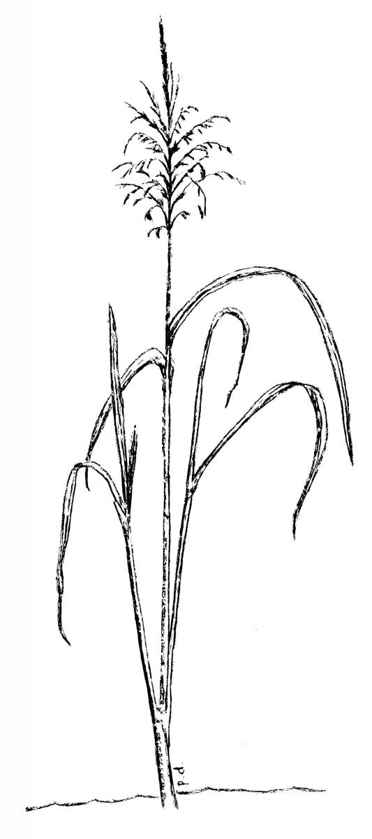
Wild rice (manoomin) is the “food that grows on water”, whose presence fulfilled the prophecies foretold in the Anishinaabe’s migration from the east. It is used in our daily lives, ceremonies, and feasts (Our Manoomin, Our Life). It is also recognized as a preferred source of food for migrating waterfowl and has high ecological value for both wildlife and fish habitat. It can also help to maintain water quality by securing loose soil, tying up nutrients, and slowing winds across shallow wetlands. The amount of wild rice in the western U.P. has declined from historic levels due mainly to water fluctuations from hydro dams and degradation of water quality from logging and shoreline development over the past century. In 1991, there wasn’t any wild rice present in our area, although historically it was thought to have been here and on lakes in areas named “Rice Lake”. In 2003, The Keweenaw Bay Tribal Council affirmed the community’s interest in a wild rice program on the L’Anse Indian Reservation (KBIC Integrated Resource Management Plan).
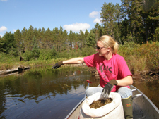
Our original focus was on three wetland systems: Sand Point Sloughs, Pinery Lakes, and Mud Lakes. In 1999, we expanded to include Robillard Impoundment. In the last 10+ years KBIC has planted thousands of pounds of wild rice seed at 13 sites within Baraga County. Wetlands that have had wild rice present in the last 5 years are surveyed annually. Seeding each year is dependent on seed available, and varies from year to year. Human and natural disturbance and consumption of wild rice by wildlife, mainly waterfowl, has impacted establishment and abundance of wild rice in seeded areas. Huron Bay has a possible 35 acres of wetlands with favorable conditions for wild rice, the largest site bordering the reservation. In 2011 there weren’t as many plants but we had unusual seiche activity which may have uprooted many of the plants. This continues to be a promising area which we planted in Fall 2012. Our long term goal is to develop harvestable self-sustaining wild rice populations on the reservation and within the ceded territory for future generations.
Wild Rice Habitat Study (EPA Great Lakes Tribal Initiative Funding 2016-2018)
The purpose of this two year study was to assess the quality of wild rice habitat in the Western Upper Peninsula or Michigan. Funding was provided by the U.S. Environmental Protection Agency under a Tribal Initiative funding program. This project supports KBIC in continuing efforts to rehabilitate a culturally significant resource in the Lake Superior basin. The project area for the Wild Rice Habitat Study is the 1842 Treaty Territory. While there are several wild rice waters within the boundaries of the L’Anse Reservation, majority of the restoration areas are located off reservation under State or Federal jurisdiction, but within the Ceded Territory (Map). The State of Michigan, U.S. Forest Services, Lac Vieux Desert Band of Chippewa Indians (LVD), and Great Lakes Indian Fish and Wildlife Commission have been important partners in wild rice restoration.
Recent studies are focusing on the aquatic and sediment environmental factors which are conducive to wild rice growth (Minnesota Department of Natural Resources. 2008; MPCA, 2017). Wild rice is becoming an “indicator species” that with its presence or absence gives information on the relative water quality in a body of water (University of Minnesota, 2008). Regional collaborative efforts concerning wild rice are being made between Minnesota Pollution Control Agency, University of Minnesota, and tribes and agencies in Michigan and Wisconsin. Wild rice studies include testing of the surface water surrounding the plant, the pore water that is within the interstices of the sediment at the wild rice roots, and the sediment itself. Recent studies are showing the deleterious effects on rice of sulfide and methylmercury in the pore water (Pastor et al, 2017), the relationship between sulfate in surface water to sulfide in the pore water (MPCA, 2017), and the increases in nutrients and mercury in relation to sulfide (Myrbo, et. al., 2017). Tribes in this region are actively working to protect and restore wild rice beds in water bodies that will support them. This study will add to the body of existing knowledge, be shared with other groups, and provide information for actively managing wild rice lakes to promote increased production and enhance conditions for natural production in order to improve waterfowl habitat and to provide a culturally important resource for the Community.